Using A Tide Table
Based on article by Mel Neale for Boat US
Tide tables tell you three important things for any given place: time of high tide, time of low tide, and heights of each. Here's how to figure out the times in between.
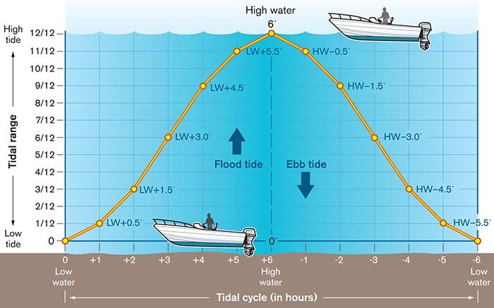
When you need to know approximately how much water is below your boat for a particular time of day, in a particular place, and you have access to the tide tables, the "Rule of Twelfths" will serve you well. It's an easy-to-use guide for "semi-diurnal" tides, which means there are two nearly identical complete tidal cycles a day (high, low, high, low, all within approximately 24 hours).
Basically, it takes about six hours for this tide to completely rise (flood) or fall (ebb). The "slack" period (when the tide is reversing directions) varies in duration depending upon your location, the stage of the moon, the force of the wind, and other factors. Slack tide may last only a few minutes or much longer, and doesn't necessarily correspond to the exact time of high and low tide.
The times of high and low tides, as well as tidal heights above or below chart datum (the numbers showing depths on your chart) for each day, can be determined from a number of sources, such as weather broadcasts, tide tables, navigation programs, some charts, and books such as Eldridge Tide and Pilot Book, published annually. If you're coastal cruising, keep a print version of the tide tables aboard for times when electricity and Internet connections are unavailable.
Find the NOAA tide tables for free at tides and currents.
For simplicity, let's use a 6-foot tidal range (range = difference between high and low tide heights). The range should be divided into 12 parts: 6 divided by 12 = half a foot. The tide will rise or fall one-twelfth in the first and sixth hours, two-twelfths in the second and fifth hours, and three-twelfths in the third and fourth hours.
Wind can affect tides by "piling water up" in or out of a short creek, or up, down, across a broad bay. When blowing for long fetches across the ocean or bays, wind can cause deeper water along the beach, and vice versa.
Keep in mind that all this is approximate and can be affected by phenomena such as high winds and storm surges. Also, in some parts of the world (for example, most areas of U.S. Gulf Coastal States, eastern Mexico, and some Caribbean Islands) tide cycles are "diurnal" (only one 12-hour rise and fall in each 24-hour period). Diurnal tidal areas often have weak currents with long periods of slack and little tidal range. Some areas have a mixture, where highs and lows are unequal and irregular. You will see this reflected in the tide charts. There are other exceptions where wind plays a predominant role, and depending on which way it is blowing on the water's surface, can make depths different from what you see in the tide tables. Always combine what the books say with what you observe around you